

Table of Contents
Some links on posts are affiliate links and will earn us a commission from qualifying purchases
When you’re out hiking across the British countryside, you might notice unusual steps running across a hillside. They can look like long, grassy banks, shallow hollows or a series of terraces cut into the slope. At first glance, they may seem like natural features, but many are reminders of how people farmed the land centuries ago.
These features are known as lynchets, or strip lynchets when they form a series of long, parallel terraces. They developed as repeated ploughing and the gradual movement of soil downhill created raised banks and flatter strips of ground. In some cases, they were also influenced by field boundaries and deliberate terracing.
Lynchets are particularly interesting for walkers because they reveal a hidden side of the countryside. The fields, ridges and banks you pass on a walk may preserve traces of farming that took place hundreds or even thousands of years ago.
Once you know what to look for, you may start noticing these subtle features on hillsides, particularly across southern England’s chalk downland and other landscapes with a long history of cultivation.
Key Takeaways
- Lynchets are historic hillside terraces formed through a combination of ploughing, soil movement and, in some cases, deliberate terracing.
- Strip lynchets appear as parallel, stepped ridges running across a slope, creating flatter areas that were useful for growing crops.
- They can be centuries old, although their precise age varies from one site to another.
- They are part of Britain’s historic landscape, offering clues about how earlier communities farmed the land.
- Walkers can often spot them from footpaths by looking for regular steps, grassy banks and changes in the shape of a hillside.
What Are Lynchets?
A lynchet is a terrace or bank on a slope, usually associated with historic agriculture. It often consists of a relatively flat strip of ground above a steeper bank, creating a noticeable step in the hillside.
Imagine walking across a field on a gentle slope and discovering that the ground suddenly rises into a long, grassy ridge. Beyond it, another flatter strip appears, followed by another bank. If the pattern continues across the hillside, you may be looking at a series of lynchets.
These features developed over long periods as farmers cultivated sloping ground. Ploughing disturbed the soil and gradually moved it downhill. Soil also moved naturally under gravity, while banks, hedges and other field boundaries helped trap the material.
Over time, the repeated movement and accumulation of soil could produce the stepped appearance we see today.
Lynchets vary considerably. Some are little more than subtle changes in ground level, while others form substantial banks that stand out clearly against the surrounding landscape.
For walkers, the key is to look beyond the immediate shape of the hill. A slope that appears uneven or unusually regular may actually preserve the outline of an old farming system.
How to Recognise a Lynchet on a Walk
You don’t need to be an archaeologist to recognise the possible signs of a lynchet. A few simple features can help you identify one as you explore the countryside.
Look out for:
- Parallel ridges: several long banks running in roughly the same direction across a hillside.
- Flat strips between banks: areas of relatively level ground separated by steeper slopes.
- A stepped profile: the hillside appears to rise or fall in a series of distinct stages rather than following one continuous gradient.
- Changes in vegetation: deeper soil on a bank or terrace may support different plants from the surrounding ground.
- Nearby historic features: old field boundaries, earthworks, ancient settlements or hillforts may provide useful clues about the landscape’s history.
Not every grassy bank is a lynchet, of course. Natural erosion, modern field boundaries and other historic earthworks can produce similar shapes. The pattern of the features and their relationship to the surrounding landscape are often more informative than any single bank.
Positive and Negative Lynchets
Archaeologists sometimes distinguish between positive and negative lynchets. The terms describe two different effects of soil movement.
A positive lynchet is a raised bank created where soil has accumulated, often along the lower edge of a cultivated strip. Repeated ploughing can gradually move soil downhill, allowing it to build up over time.
A negative lynchet forms where soil has been removed from the upper side of a slope, leaving a hollow, cut or steeper edge.
The two features can occur together. As soil is moved from the upper part of a cultivated strip, it may accumulate farther downhill, leaving a hollow above and a raised bank below.
When walking across an area containing several lynchets, look at the overall shape of the slope rather than concentrating on individual banks. The pattern may reveal how soil moved and how the land was divided into separate areas for cultivation.
Strip Lynchets and Stepped Hillsides
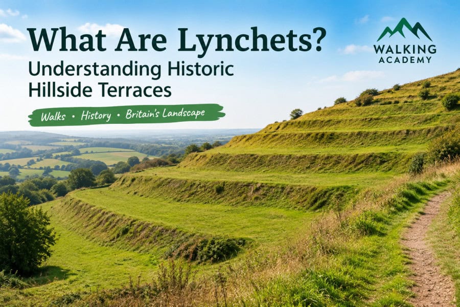
Strip lynchets are particularly recognisable because they form a series of long, narrow terraces across a slope.
Each terrace has two main parts:
- The tread is the flatter area that could be cultivated.
- The riser is the steeper bank separating one terrace from the next.
Together, these create the familiar staircase effect seen on some historic hillsides.
The terraces often follow the contours of the land, although their precise shape and arrangement vary. Some are narrow and regularly spaced, while others are broad or irregular.
Many are associated with medieval farming, including the cultivation of strips within open-field systems. Others may belong to earlier agricultural landscapes, and some features were modified or reused over time.
For walkers, these terraces are a reminder that a hillside which now supports grass, woodland or pasture may once have been carefully organised for growing food.
How Were Lynchets Formed?
Lynchets developed through a combination of human activity and natural processes. Repeated cultivation was often important, but the movement of soil, the shape of the slope and the presence of boundaries all played a part.
The process was gradual. A bank that looks well established today may reflect generations of farming rather than a single construction project.
Ploughing and Soil Erosion
Traditional ploughing disturbed the soil and could move small amounts of earth downhill with each pass. Although the movement was limited on any one occasion, it accumulated over many years.
Where farmers cultivated sloping ground, soil could gradually collect along the lower edge of a field or strip. This produced a raised bank, while the ground farther uphill became progressively lower.
The amount of soil moved depended on factors such as the steepness of the slope, the type of soil, the direction of ploughing and the tools being used.
In some places, the result was a clearly defined terrace. Elsewhere, the changes were much more subtle.
When you walk through an area of historic farmland, these differences can help explain why one hillside has pronounced steps while another appears almost smooth.
The Slow Movement of Soil
Ploughing was not the only process involved. Soil also moves naturally downhill under the influence of gravity, a process known as soil creep.
This movement is extremely slow, but over long periods it can contribute to the reshaping of a hillside. Rainwater can also wash loose material downhill, adding to the accumulation of soil at lower levels.
Where these natural processes interact with repeated cultivation, terraces can become more pronounced.
The result is a landscape shaped by both people and nature. Farmers altered the ground to grow crops, while gravity, weather and erosion continued to influence its appearance.
The Role of Field Boundaries
Banks, hedges, walls and ditches could help determine where soil accumulated. By creating a boundary across a slope, they could trap material moving downhill and encourage the development of a raised edge.
Some terraces may also have been deliberately created or modified to make sloping ground easier to cultivate.
This means that lynchets should not all be assumed to have formed in exactly the same way. Their appearance reflects the particular combination of farming methods, soil conditions and land management at each site.
For hikers, this is part of the fascination. Two apparently similar hillsides may have quite different histories, even if their terraces look almost identical from a distance.
The History of Lynchets in Britain
Lynchets are valuable clues to the history of Britain’s rural landscape. They can reveal where communities cultivated sloping land, how fields were arranged and how agricultural practices changed over time.
However, identifying a lynchet does not automatically tell you its age. Some terraces are associated with medieval farming, while others may have much earlier origins. Later cultivation can also alter older features, making their history more complicated to interpret.
Ancient and Historic Farming Landscapes
Many lynchets survive as part of larger historic field systems. These may include old boundaries, ridge-and-furrow earthworks, trackways and other traces of past agriculture.
Some are associated with prehistoric field systems, including arrangements of small plots sometimes described as Celtic fields. Others are linked to later periods when communities cultivated long strips of land across open fields.
The size and shape of the terraces, their relationship to nearby features and archaeological evidence can all help researchers understand how they were used.
When you’re walking through the countryside, it is worth looking at the wider landscape. A series of grassy banks beside an ancient trackway or near an old settlement may form part of a much larger pattern of historic land use.
Medieval Farming and Strip Lynchets
Many of the best-known strip lynchets are associated with medieval agriculture.
During the medieval period, much farmland was organised into open-field systems, with individual holdings divided into strips. Cultivating sloping ground could produce terraces as soil moved downhill and accumulated along the edges of these plots.
The resulting banks sometimes remain visible long after the original field system disappeared.
In places, the terraces are broad and regularly spaced. Elsewhere, they are irregular, perhaps reflecting changes in cultivation or the reuse of land over several periods.
The presence of lynchets can therefore offer an insight into the organisation of medieval farming, although archaeological evidence is needed to establish the history of an individual site.
Prehistoric and Earlier Terraces
Some lynchets and related terraces are associated with earlier agricultural landscapes, including those dating to prehistoric times.
Archaeologists study buried soils, artefacts, environmental evidence and the layers of material accumulated around the terraces to investigate their origins. Techniques such as radiocarbon dating and optically stimulated luminescence can help establish when particular deposits formed.
These methods are important because the appearance of an earthwork alone rarely provides a precise date.
For walkers, the important point is that some seemingly ordinary field boundaries and grassy steps may be remnants of landscapes that were being cultivated long before the villages and farms we see today were established.
Where Can You Find Lynchets in Britain?
Lynchets occur in several parts of Britain, although their visibility and distribution vary with geology, topography and the history of land use.
Southern England is particularly well known for historic agricultural earthworks, including terraces on chalk downland and other sloping farmland.
The North and South Downs
The chalk landscapes of the North Downs and South Downs provide good places to look for historic field systems and earthworks.
As you walk along a ridge or across a hillside, watch for parallel grassy banks and changes in slope that seem too regular to be entirely natural.
Some features are easier to recognise from a higher viewpoint, where the arrangement of the terraces becomes clearer. Others may only become apparent as you cross a field or follow a footpath along the contour.
The wider setting can be just as interesting as the terraces themselves. Historic field systems may sit close to ancient settlements, burial monuments and other archaeological features.
Salisbury Plain and the Chilterns
Salisbury Plain and parts of the Chilterns also contain extensive traces of historic land use, including earthworks associated with earlier farming.
These landscapes are particularly rewarding for anyone interested in the history beneath the countryside. Ancient monuments, old field systems and later agricultural features can occur within the same wider landscape.
Not every earthwork in these areas is a lynchet, so it helps to look for the characteristic combination of a flatter strip and a bank or step across sloping ground.
The Yorkshire Dales and Other Upland Areas
The Yorkshire Dales and other upland landscapes contain terraces and related agricultural earthworks, although the local forms and their origins can differ from those found on southern chalk downland.
Stone walls, old field boundaries and changes in the shape of a slope may all contribute to the character of these historic landscapes.
If you’re exploring an upland footpath, look for old terraces on valley sides and around former areas of cultivation. Some may now be grass-covered or partly hidden by vegetation, making them difficult to distinguish without a little local knowledge.
Lynchets Beyond Britain
Similar agricultural terraces occur in parts of mainland Europe, including areas of Belgium, the Netherlands, Germany and France.
Their appearance reflects local farming traditions, soil conditions and the ways communities adapted sloping land for cultivation.
Although the terminology varies between countries, the underlying idea is familiar: people have shaped hillsides for centuries to make productive use of the land.
How Archaeologists Study Lynchets
Many lynchets are subtle features, and some are difficult to recognise from ground level alone. Archaeologists use a range of techniques to map them, investigate their origins and understand how they fit into the surrounding landscape.
Aerial Photography and LiDAR
Aerial photographs can reveal patterns that are difficult to see while walking through a field. From above, parallel terraces and old field boundaries may form a much clearer picture.
LiDAR, which uses laser measurements to map the ground surface, can also help reveal earthworks beneath woodland or dense vegetation. The resulting terrain models make it easier to identify banks, hollows and changes in slope.
Historic England and other organisations provide mapping and historic environment information that can help researchers investigate these features.
Walkers interested in exploring the history of a particular area can sometimes use publicly available mapping to identify likely earthworks before setting out. However, not every mapped feature will be visible on the ground, and some will be difficult to identify without specialist knowledge.
Dating the Terraces
Establishing the age of a lynchet can be challenging because the feature may have developed gradually or been modified during different periods.
Radiocarbon dating can help establish the age of suitable organic material found in archaeological deposits. Optically stimulated luminescence dating can help determine when mineral grains were last exposed to sunlight before being buried.
Archaeologists also examine soil layers, pottery and other finds, along with evidence from nearby settlements and field systems.
Combining these sources of information can build a clearer picture of when a terrace formed and how it was used.
What the Soil Can Tell Us
Excavation and soil analysis can reveal buried ground surfaces, traces of cultivation and layers of material deposited over time.
Environmental evidence, including preserved plant remains and pollen, may help researchers understand what was growing in the surrounding landscape.
These investigations can reveal more than the age of a terrace. They may also provide clues about agricultural practices, changes in vegetation and the way communities used the land.
The next time you cross a grassy bank on a walk, remember that its history may be far more complex than its modest appearance suggests.
Protecting Lynchets and Enjoying Them on a Walk
Lynchets are part of Britain’s archaeological heritage. Although many appear as ordinary grassy banks, they can preserve valuable evidence of past farming and settlement.
Their survival depends partly on how the land is managed today. Deep ploughing, erosion, construction and other ground disturbance can damage or remove historic earthworks. In some locations, scrub and trees can also obscure their shape.
Conservation bodies, landowners and local authorities may record or protect important sites as part of the wider historic landscape.
How Walkers Can Help
If you come across what looks like a lynchet, the best way to appreciate it is to observe the feature without disturbing it.
A few simple habits help protect the landscape:
- Stick to public footpaths and respect signs, gates and access restrictions.
- Avoid climbing steep banks or cutting across fragile earthworks unnecessarily.
- Take photographs from the path or another suitable viewpoint.
- Look for information about the area’s history through local heritage records or guidebooks.
- Leave any archaeological objects where they are and follow the appropriate guidance if you discover something that may be significant.
You can also investigate the area before your walk. Historic maps, local archaeological records and terrain mapping may help you understand what you are likely to see.
Reading the Landscape as You Walk
One of the pleasures of walking is discovering that the countryside is full of clues to its past.
A hollow beside a path might mark an old boundary. A grassy ridge could be the remains of a former field edge. A series of steps across a hillside might reveal where generations of farmers cultivated the ground.
Lynchets are particularly rewarding because they are often easy to overlook until someone explains what they are.
Once you recognise the pattern, you may start seeing the landscape differently. Instead of a simple grassy slope, you begin to imagine the fields that once occupied it, the people who worked the land and the gradual changes that have shaped the countryside over centuries.
That extra layer of understanding can make an ordinary walk much more interesting.
Frequently Asked Questions About Lynchets
What is a lynchet, and how can I identify one on a hillside?
A lynchet is a terrace or bank on a slope, usually associated with historic farming. Look for a flatter strip of ground above a steeper bank, particularly where several similar features run parallel to one another across a hillside.
The pattern is often easier to recognise when viewed from a suitable higher point or on a map showing the shape of the land.
How were lynchets formed? Are they natural or man-made?
Most agricultural lynchets developed through a combination of human activity and natural processes. Repeated ploughing moved soil downhill, while gravity, rainwater and other forms of erosion contributed to its movement.
Field boundaries could trap the soil, creating raised banks and hollows. Some terraces may also have been deliberately shaped or modified for cultivation.
Why did historic farmers create terraces on hillsides?
Terraces provided flatter strips of ground that were easier to cultivate than a continuous slope. They allowed farmers to make use of land that might otherwise have been difficult to plough or manage.
The precise benefits varied according to the slope, soil and farming methods used.
What is the difference between a lynchet and a strip lynchet?
A lynchet is a general term for a terrace or bank associated with cultivation on sloping ground.
Strip lynchets are a particular pattern of terraces that form a series of long, parallel strips. They are often associated with historic arable field systems and can create a distinctive staircase effect across a hillside.
Where are lynchets most common in the UK?
Lynchets are found in various parts of Britain, with notable examples in southern England, including the North Downs, South Downs, Salisbury Plain and the Chilterns. Related terraces and historic agricultural earthworks also occur in other regions, including upland areas.
Their distribution reflects the combination of suitable slopes, soil conditions and a long history of cultivation.
How old are lynchets?
Their age varies considerably. Some are associated with medieval farming, while others may belong to prehistoric or earlier historic field systems. Later agricultural activity may also have altered older terraces.
Archaeological evidence is usually needed to establish the age of a particular site.
How can I tell a lynchet from ridge and furrow?
Lynchets generally appear as banks or steps running across a slope, often with a flatter strip above a steeper edge.
Ridge and furrow consists of a pattern of long ridges and hollows created by historic ploughing. The two features can occur in the same wider landscape, so their relationship to the slope and surrounding field patterns can help distinguish them.
Modern terraces may have more obvious engineered edges, retaining walls or drainage features, although appearance alone is not always conclusive.
Can I walk across lynchets?
You may be able to view lynchets from public footpaths or other permitted access routes, depending on where they are located. Follow local access rules, respect landowner signs and avoid damaging fragile banks or steep faces.
If a lynchet lies within a field without public access, do not cross the land simply to get a closer look.
Final Thoughts
Lynchets are a wonderful example of how much history can be hidden in an ordinary-looking hillside. Those grassy steps and ridges are often the surviving traces of farming systems that shaped the British countryside over many generations.
The next time you’re walking across the Downs or exploring an old agricultural landscape, take a moment to look at the shape of the ground. A series of parallel banks might reveal where crops once grew and how earlier communities adapted the land to feed themselves.
You don’t need to be an expert to appreciate these features. A little curiosity and a closer look at the landscape can turn a familiar footpath into a journey through Britain’s agricultural past.
Discover what lynchets are, how these historic hillside terraces formed, and where to spot these fascinating traces of ancient farming on your UK walks.
Recent Posts
Roundhouse Explained: Life and Architecture in Ancient Britain
When hiking through the UK countryside, you’ll often spot subtle grassy rings or stone outlines on hillsides and moors. These are the footprints of roundhouses - the primary homes used across...
What Is a Dolmen? Exploring Ancient Burial Sites for Walkers
You will spot dolmens as simple stone tables on walks across moors, coasts, and river valleys - they are single-chamber megalithic tombs built in the Neolithic to hold the dead and mark important...